
If you’ve been tuned into the San Onofre Shoreline Resilience Project from the start, welcome back!
If you’re just peeking below the surface, we’re happy to have you.
While you’ll likely be able to follow along as is, consider browsing through the past Community Assembly recaps to get fully up to speed
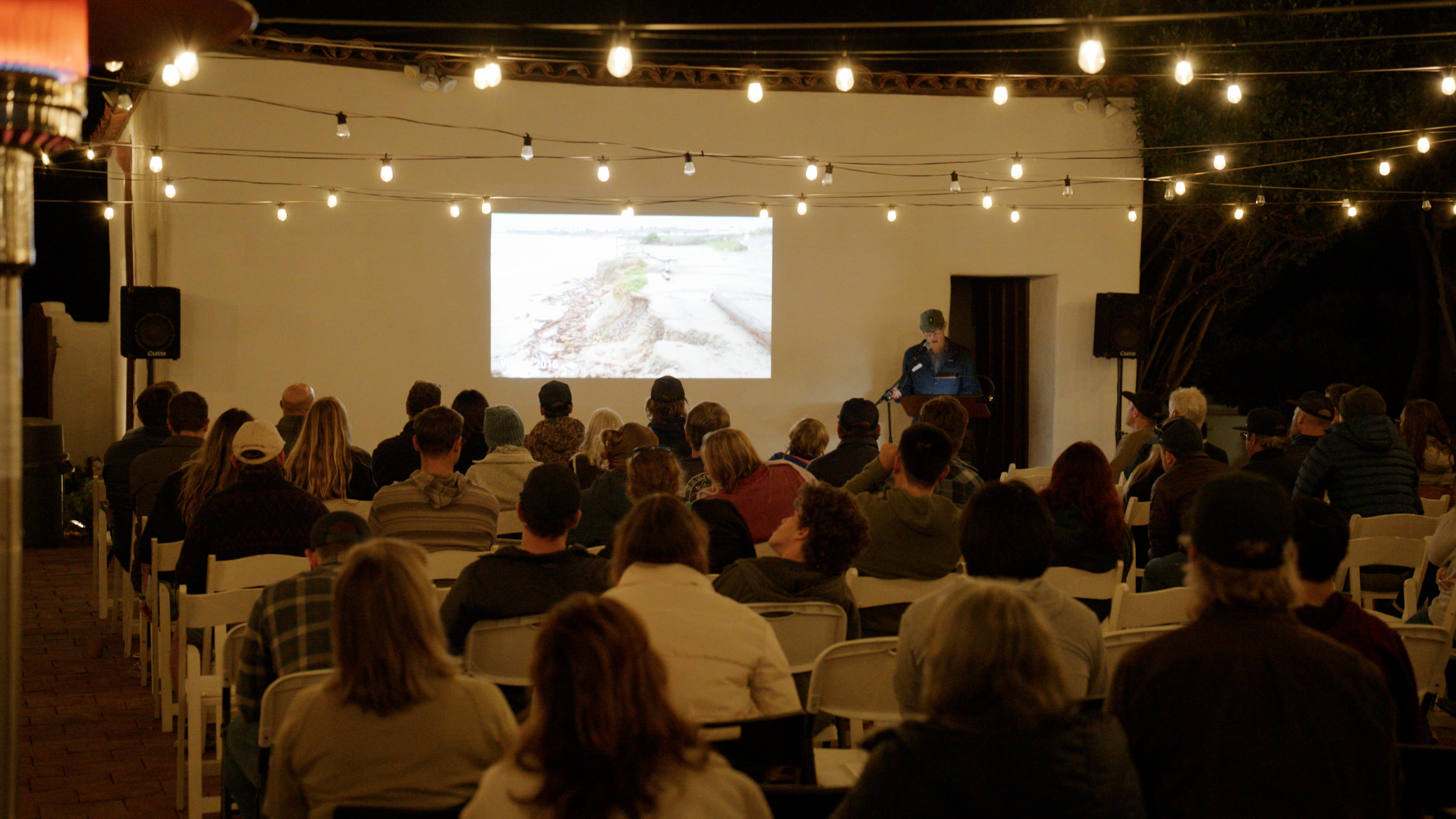
On Saturday, November 7, around 130 people filed into the San Clemente Historic Cottage to the final Community Assembly of the San Onofre Shoreline Resilience Project to hear the latest on Surf Beach and what a pathway forward could look like.
Not to miss the hundred plus who joined us virtually during their lunch hour on 11/9.
Watch the recording HERE
The State of the Beach
After opening words from Juaneño Band of Mission Indians Acjachemen Tribal Chairman Nathan K Banda, Riley Pratt, Ph.D., Senior Environmental Scientist with the Orange Coast District of California State Parks, kicked off the presentation with a slight deture, offering us a virtual tour of the beach as it looked the Friday before the assembly.
In a word, he said, Surf Beach is dynamic.


While the state of San O looks grim, the good news is that a beach can look rough and still recover, both naturally and through intervention. (Surfer’s Point is living proof of that!) And while this is gearing up to be an exceptional El Niño season, a wet winter could also deliver new sediment to the shoreline.
Immediate Access and Winter Operations
Due to the frequent overtopping events, State Parks is currently planning to keep the lower beach lot closed through this winter.
In the meantime State Parks is working quickly to implement the following access alternatives the community uplifted over the spring of this year:
- Building a natural surface trail down the bluff, near the existing bluff top trail, to reach the middle section of San O.
- Once that trail opens, the entrance waiting line area will become temporary parking for roughly 85 to 90 cars.
- Adaptive surfers and people with mobility disabilities would be directed utilize the paved lower lot, with the possibility of developing a nearby launch site being developed by State Parks leadership (closer than dog patch) for adaptive surf craft.
The Recommended Alternative
James Jackson, civil and coastal engineer and hydrologist leading the project for Environmental Science Associates (ESA), walked through how the team honed from nine options to one.
The goal: a nature-based shoreline concept for Surf Beach that:
- Reduces wave overtopping and erosion damage to the parking lot and facilities
- Keeps safe access to the beach and surf breaks
- Protects coastal, ecological and cultural resources.
The time horizon: this design is tested to meet those goals through 2049, the end of the current USMC lease, which corresponds to about one foot of sea level rise.
How the options were scored:
For technical review, each option was rated Low, Medium or High on six criteria, weighted equally, for a maximum of 30 points:
- Access, parking and facilities
- Surfing and beach recreation
- Hazard reduction and public safety
- Nature-based design and resources
- Sea level rise adaptation and upkeep
- Feasibility, cost, permitting and support
Ratings drew on professional judgment, prior studies, new site evaluations and community input.
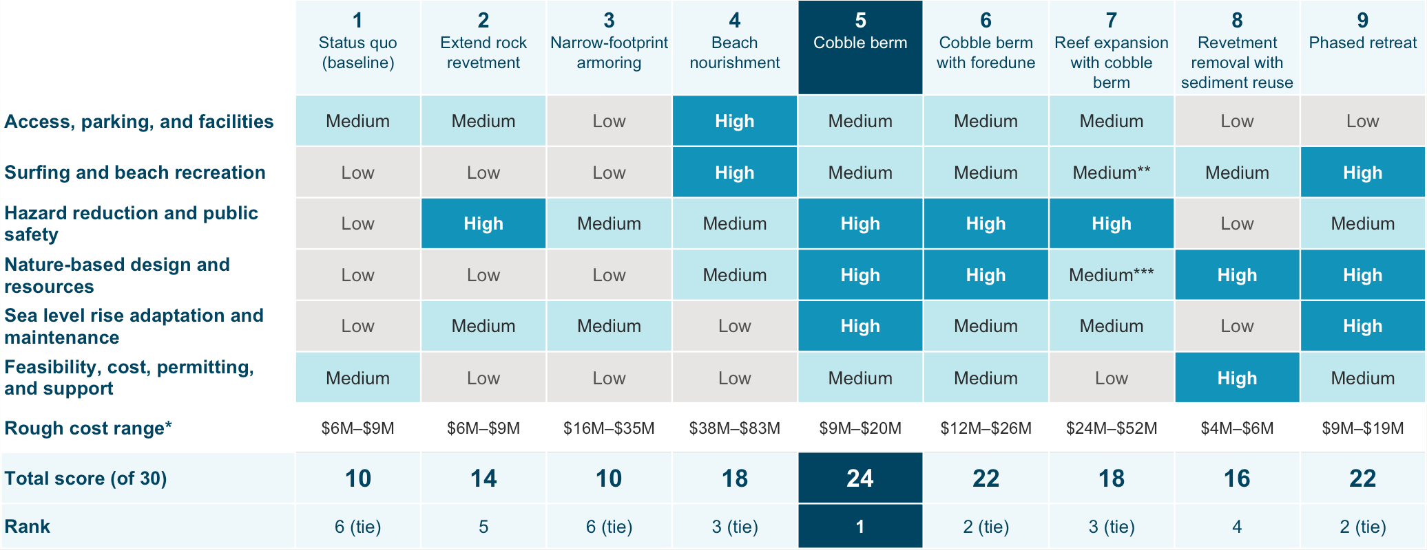
Costs are rough order-of-magnitude estimates for construction plus 25 years of maintenance, in 2026 dollars, and could land 30% lower to 50% higher depending on inflation.
Community Input:
Out of the choices given during the spring Assembly (and long running virtual survey), the alternatives ranked similarly, with a cobble berm being the highest, and seconded by one point difference, to allowing erosion.
Our champion! Cobble.
But, why cobble?
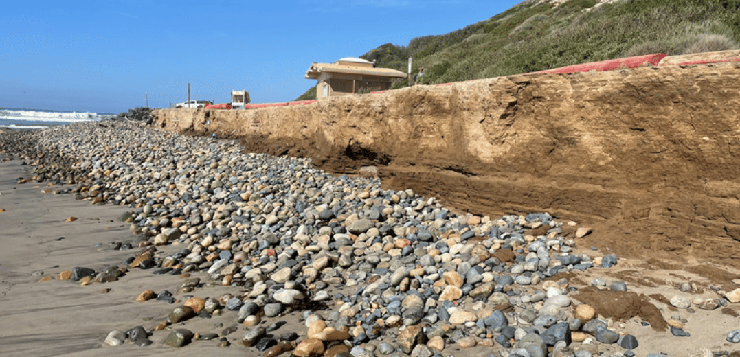
Surf Beach is a cobble beach at its foundation.
Last year we saw cobble build within the flanking scarp, and already this year you can see natural cobble berms forming along the shoreline at Green Beach (Military Recreation Beach) and in front of the bluff near SONGS.
A cobble berm would significantly nourish that existing feature to an amount that is wide enough to absorb wave energy and remain largely intact throughout the seasons.
Specs:
- Uses rounded cobble like the natural beach, bluff and reef (likely sourced from geographically similar inland prehistoric river sites)
- Absorbs wave energy with much less reflection, reducing scarping and erosion
- Designed to mimic the beach slope, so it allows seasonal sand recovery
- Adjusts naturally, dynamically moving up and landward during big storms and as sea levels rise
- Keeps lateral access along and across the beach
As with any alternative, there are tradeoffs the team is designing around. When cobble is exposed, it is harder to walk on than sand in, which matters for beach access and for the adaptive surfing community. As it already does, the sandy beach cover will still vary seasonally. And the berm may need periodic maintenance after large storms and El Niño years.
Potential companion elements include low planted foredunes (small vegetated sand dunes between the beach and road) where the beach allows, reusing sediment that comes down the bluff;, targeted facility removal, like we saw with Restroom 2; and allowing erosion in places with room for the beach to migrate, like Old Man's and Dog Patch.
Please note: As we've seen, the shoreline is changing quickly. While this is the top contender under current conditions, we also remain open and flexible to the notion that shoreline changes could require a different response.
A Pilot for This Winter
The October 9 to 13 high tides alone showed why implementation is needed immediately.
While the swell was modest, around five to six feet of surf, El Niño and the Kelvin Wave pushed water levels more than a foot and a half above predicted tides. The result was regular overtopping and severe erosion of the parking lot.
Southern California tide gauges have since reached the 100-year tide level, and king tides around Thanksgiving and Christmas are expected to run higher still.
Erosion at The Point has reached a critical threshold, so the project team is fast-tracking a pilot cobble berm, a scaled-down version of the recommended alternative:
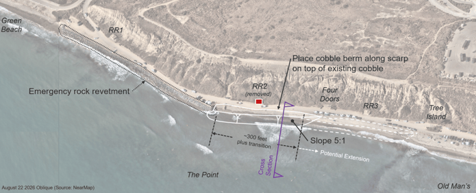
This pilot berm would fill the first ~300 feet of eroding scarp just south of the rock revetment (pictured in solid white lines above), with a crest at least 15 feet wide at about 12 feet elevation. And to leverage the most amount of information from this project as possible, monitoring is planned in partnership with Scripps Institution of Oceanography, which has RFID tracked cobble on beaches before, so we gain incredible insight into exactly how larger quantities of cobble behaves before moving on to implement anything larger.
The Project team is currently coordinating with base staff and contractors while applying for emergency El Niño funding from the Ocean Protection Council and the State Coastal Conservancy. These rapid response funding opportunities are slated to be announced and dispersed immediately.
What's Next for the SOSRP?
At this point, the long-term project now moves into preliminary design.
ESA will develop the cobble berm concept to 30% design, which when complete, would signal the next step on the adaptation pathway of permitting and final engineering after approval (not currently funded within this project).
This wraps up the community engagement phase of the current grant supporting the work. That said, like you did before this project was funded, we’ll still be busy at work and updating you as we go.
FAQ
Here are some recurring questions answered at both the virtual and in person Assemblies:
Q: Why not just add sand to the beach? Why cobble?
A: While beach nourishment is not a preferred solution by Surfrider, beach nourishment was one of the e options explored. Given the long-term erosion trend at Surf Beach, sand would need to be replaced over and over, which made it one of the most expensive and maintenance heavy alternatives.
Q: Where does the next round of funding come from?
A: Thanks to voters, there is state money set aside for resilience efforts via Prop 4. Once timing is appropriately aligned with the end of our current grant funding, we’ll be submitting applications for the next phase through the various rolling state opportunities. Unfortunately due to large scale divestment from infrastructure projects and disaster relief at the federal level, it is unlikely that federal opportunities open up to fund projects like this.
Q: Has carving into the bluff been considered?
A: Creating more space landward is one of the most attractive companions to anything we can do seaward or the road. This is made complicated by the constraints of the lease and the USMC’s environmental mitigation site on top of the bluffs.
Q: Is there any way to leverage the upcoming LA28 Olympics to support the work at Surf Beach?
A: We certainly hope that having the globe’s eyes trained on San Onofre State Beach, will result in motivation to improve the conditions of Trestle’s sister beach. As of now, no opportunities of that scale have been identified.
Stay Updated
If you would like to stay informed and receive updates regarding the San Onofre Shoreline Resilience Project and the state of the beach, simply sign up below.
The San Onofre Shoreline Resistance Project is supported by the California State Coastal Conservancy, in partnership with the Juañeno Band of Mission Indians Acjachemen Nation, California State Parks, San Onofre Parks Foundation, California Indian Culture and Sovereignty Center, Environmental Science Associates, and the San Onofre Surfing Club |




 As Surfrider's Coastal Preservation Manager, Alex (she/her) focuses on coastal resiliency projects centered around nature-based solutions. She has worked on the ocean as a naturalist and passionately seeks to connect new folks with the sea by linking core memories on the water with education about the impact of marine preservation.